Moonshadow News

DKS Associates and Moonshadow Announce Partnership to Provide New Intelligent Transportation Solutions

By |January 6th, 2017|

FOR IMMEDIATE RELEASE
January 6, 2017

PORTLAND, Ore. – DKS Associates and Moonshadow Mobile announce a new partnership to collaborate on the development and deployment of cutting-edge solutions for Connected and Autonomous Vehicles and other data-intensive applications. The partnership will leverage DKS’s vast experience in providing transportation planning, engineering, and implementation services with Moonshadow’s groundbreaking time-series database engine technology.

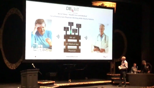
Moonshadow’s “DB4IoT” is a patented database engine for the Internet of (Moving) Things. DB4IoT can track and display the GPS location, vehicle health, diagnostic, and other sensor data, from tens of thousands of moving objects simultaneously over interactive maps. This provides the ability to […]

Moonshadow’s Ground Game® Featured in Techradar Article

By |April 20th, 2016|

Techradar writer James O’Malley authored a recent online article titled “In Election 2016, the war for your vote has become the war for your data.” O’Malley quotes Moonshadow President Bob Lee, our political data partner L2’s Paul Wescott, Microsoft’s Stan Freck and others in an overview discussing how data about registered voters and campaign software and mobile apps (such as Moonshadow’s Ground Game and L2’s VoterMapping) are impacting the 2016 election cycle.

O’Malley goes into depth describing the richness of L2’s “data dictionary” with examples of some of the many data points made available to political campaigns that go far […]

DB4IoT at Angel Oregon 2016

By |April 20th, 2016|

Eimar Boesjes, Moonshadow CEO, gives a presentation to the 2016 Angel Oregon Conference on April 13th in Portland, Oregon. DB4IoT is Moonshadow’s cloud database platform built for the demands of time-series Internet of Things (IoT) data.

Time, location, temperature, pressure, humidity, flow, speed, direction, current, voltage etc. – whatever measurements your IoT devices’ sensors capture DB4IoT is a hassle-free and affordable way to store that Internet of Things data and make it available for analytics and visualization.

The Internet of Things poses unprecedented challenges for database administrators in terms of sheer data volume and therefore scalability, flexibility, accessibility and connectivity.

With DB4IoT you’ll […]

L2 VoterMapping – Powered by Moonshadow – Used by CBS News and NY Times

By |February 24th, 2016|

L2 VoterMapping and is being used by CBS News and the New York Times as a tool to enhance their 2016 election coverage.

L2 VoterMapping is a voter analysis and data selection tool unlike any other. VoterMapping technology – powered by Moonshadow’s Ephemeris database technology – arms candidates, consultants, pollsters, political organizations, academic researchers, public affairs professionals and government agencies and more with data visualization and analysis capabilities unavailable anywhere else. Display and analyze millions of records instantly, visualizing your result geo-spatially with Bing Maps…all in real time.

The combination of the most accurately processed voter data available and the speed of […]

Moonshadow Wins $400,000 Investment at the 2015 Willamette Angel Conference

By |May 22nd, 2015|

Eugene, Oregon-based Moonshadow Mobile, Inc. took home the biggest investment of more than $400,000 at the 2015 Willamette Angel Conference presented by the Corvallis Chamber of Commerce, Corvallis Benton County Economic Development Office, and the Eugene Area Chamber of Commerce on May 15th.

The final amount will be tallied later, but it is expected to be the largest investment that the group has funded to date, said Dave Hauser, president of the Eugene Area Chamber of Commerce, one of the founders/partners in the conference. “Often once the company is determined, some WAC investors buy additional shares,” he said. The WAC is […]

Population Data as 3D Organic Structures

By |January 18th, 2015|

Here’s a thing that has intrigued me for years: wouldn’t it be cool if we could convert our population databases with hundreds of millions of records into 3D models and fly through them.

Over the last few months we – finally – developed the technology to convert big databases into 3D models in a matter of seconds. After the model has been converted you can ‘fly’ through it in real time. We are using OpenStreetMaps for the underlying maps. This blog posting is the first time we are publishing images from the 3D models. I choose some of the more artistic […]